
Page 10 - SST Class 03
P. 10
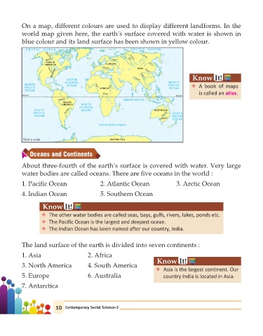
On a map, different colours are used to display different landforms. In the

            world map given here, the earth’s surface covered with water is shown in
            blue colour and its land surface has been shown in yellow colour.

              A R C T I C  O C E A N                              A R C T I C  O C E A N
                        M
                                                                        e
                                                                        L na
                                                                  i
                        acken i n
                       Yuko  z e                        Volg a  Ob
                                                                 Yen sey
                        NORTH                                             Am r
                       AMERICA                       EUROPE                 u
                                                    Danube
                            i                                        ASIA Hu
                           s issipp                                   Y   ang
                         Mis
                         souri
                           Mi s                                        ang tze                  Know       It!
                                  NORTH                            Ga g
                                                                    n es
                                 ATLANTIC                                           NORTH
             NORTH                OCEAN         Niger  N                            PACIFIC
             PACIFIC                              AFRICA  ile                       OCEAN      v A book of maps
             OCEAN
                                                    C on go                                        is called an atlas .
            Equator                                                                     Equator
                              Am azon                         INDIAN OCEAN
                                SOUTH
                                AMERICA  SOUTH
                                        ATLANTIC
                  SOUTH          Paran  a  OCEAN                             AUSTRALIA
                  PACIFIC                                                         l  g  SOUTH
                  OCEAN                                                          Dari n  PACIFIC
                                                                                Murray  OCEAN
                                                  SOUTHERN OCEAN
             Not to scale                              ANTARETICA
                Oceans and Continents
            About three-fourth of the earth’s surface is covered with water. Very large

            water bodies are called oceans. There are five oceans in the world :

            1. Pacific Ocean                       2. Atlantic Ocean                    3. Arctic Ocean

            4. Indian Ocean                        5. Southern Ocean


                      Know       It!

                      v The other water bodies are called seas, bays, gulfs, rivers, lakes, ponds etc.
                      v The Pacific Ocean is the largest and deepest ocean.
                      v The Indian Ocean has been named after our country, India.


            The land surface of the earth is divided into seven continents :

            1. Asia                         2. Africa
                                                                              Know       It!
            3. North America                4. South America
                                                                              v Asia is the largest continent. Our
            5. Europe                       6. Australia                          country India is located in Asia.

            7. Antarctica


                            10   Contemporary Social Science-3