
Page 9 - SST Class 05
P. 9
36°N 70°E 74°E 78°E 82°E 86°E 90°E 94°E
34°N
JAMMU
AND
34°N KASHMIR
LADAKH
Srinagar Leh 32°N
32°N
HIMACHAL
PRADESH
PA I K STAN Chandigarh Shimla 30°N
Chandigarh
Dehra Dun
30°N PUNJAB Dehra Dun D
ARYANA UTTAR AK AN CHINA
H
(TIBET)ET)
(TIB
H DELHI SIKKIMIKKIM L PRA 28°N
S
28°N NE L Gangtok ARU A N CHA anagar DESH
PA
Jaipur UTTAR BHUTAN It
PRADESH
Lucknow Dispur ASSAM ohima 26°N
26°N RAJASTHAN BIHAR S Shillonghillong K NAGALAND
Patna MEGHALAYA mpha l
p
Tro ic f o Ca nc r e BANGLADESH I MANIPUR 24°N
24°N Bhopal JHARKHAND WEST Agartala TRIPURA i A awl z
Gandhi Nagar Ranchi BENGAL
GUJARAT MADHYA PRADESH Kolkata MIZORAM 22°N
Raipur
22°N ORISSA
Silvassa
s w r
Diu Silvassa G RH TIS A Bhub ane h a MYANMAR
A
(Daman & Diu) DADRA AND MH AR ASHTR A
NAGAR HAVELI HHAT 20°N
20°N Mumbai C BAY
Hyderabad OF
ARABIAN BENGAL 18°N
18°N SEA ANDHRA YANAM
PRADESH
a
P n ji a (Pondicherry)
GOA 16°N
16°N
KARNATAKA
Bangluru
Chennai 14°N
14°N
PONDICHERRY
Karaikal ( Port Blair
TAMIL NADU (Pondicherry) In 12°N
12°N Kavaratti KER L A A dia)
Laksh d a weep
(I d )
n ia
Thiruvananthapuram 10°N
Thiruvananthapurm
10°N
Maldiv es I N D I A N O C E A N Not to scale 8°N
8°N
70°E 74°E 78°E 82°E 86°E 90°E
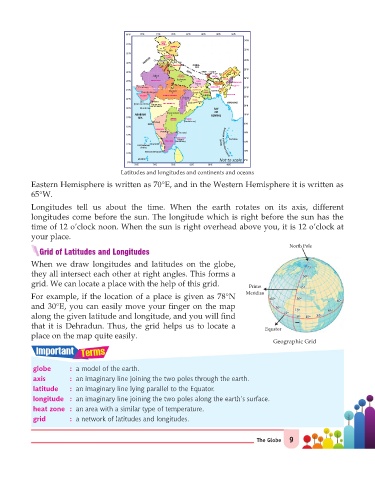
Latitudes and longitudes and continents and oceans
Eastern Hemisphere is written as 70°E, and in the Western Hemisphere it is written as
65°W.
Longitudes tell us about the time. When the earth rotates on its axis, different
longitudes come before the sun. The longitude which is right before the sun has the
time of 12 o’clock noon. When the sun is right overhead above you, it is 12 o’clock at
your place.
North Pole
Grid of Latitudes and Longitudes
When we draw longitudes and latitudes on the globe,
75º75º
they all intersect each other at right angles. This forms a 60º
60º
grid. We can locate a place with the help of this grid. Prime 45º
45º
Meridian
For example, if the location of a place is given as 78°N 30º
30º
60º60º
60º
60º
and 30°E, you can easily move your finger on the map 30º
30º
15º
15º 45º
45º
15º
15º
along the given latitude and longitude, and you will find 0º 0º 15º 30º
30º
15º
that it is Dehradun. Thus, the grid helps us to locate a Equator
place on the map quite easily.
Geographic Grid
globe : a model of the earth.
axis : an imaginary line joining the two poles through the earth.
latitude : an imaginary line lying parallel to the Equator.
longitude : an imaginary line joining the two poles along the earth’s surface.
heat zone : an area with a similar type of temperature.
grid : a network of latitudes and longitudes.
The Globe 9