
Page 21 - SST Class 04
P. 21
Malwa Plateau
The Malwa Plateau is just near the the northern plains. It extends from the Aravalli
Hills in the north-west to the Vindhyas in the south. It gradually slopes towards the
north and merges with the northern plains. Due to its northward slope, most of the
rivers of this region fall into the Yamuna River. You have read that many rivers from
the south join the Yamuna River. These rivers flow here. They rise in the Vindhyas.
These rivers are the Sind , the Betwa , the Ken and the Chambal ; all these are tributaries
of the Yamuna.
The Malwa Plateau extends over the states of southern Uttar Pradesh, Madhya
Pradesh and Jharkhand. The state of Chhattisgarh is located in the region of
Chota Nagpur which forms the richest mineral-producing area in the country. The
important minerals found here include coal, iron ore, mica, manganese etc.
Deccan Plateau
In shape, the Deccan Plateau is like a triangle. It is bounded by the Satpura Hills in the
north, Kanyakumari in the south, the Western Ghats on the west and the Eastern Ghats
on the east.
The Western Ghats are located along the Arabian Sea and their height increases
towards the south. The Western Ghats are formed by the Sahyadri Hills, the Nilgiri
Hills, the Annamalai Hills and the Cardamom Hills. The highest peak in the Western
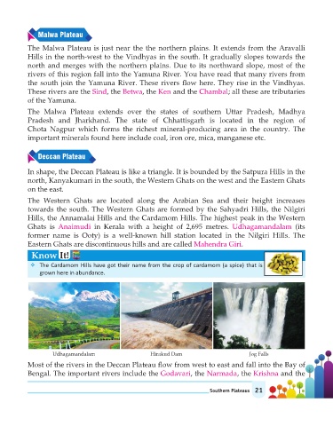
Ghats is Anaimudi in Kerala with a height of 2,695 metres. Udhagamandalam (its
former name is Ooty) is a well-known hill station located in the Nilgiri Hills. The
Eastern Ghats are discontinuous hills and are called Mahendra Giri .
Know It!
v The Cardamom Hills have got their name from the crop of cardamom (a spice) that is
grown here in abundance.
Udhagamandalam Hirakud Dam Jog Falls
Most of the rivers in the Deccan Plateau flow from west to east and fall into the Bay of
Bengal. The important rivers include the Godavari , the Narmada , the Krishna and the
Southern Plateaus 21